Thursday, February 26, 2009

East Kalimantan

East Kalimantan (Indonesian: Kalimantan Timur abbrv. Kaltim) is the second largest Indonesian province, located on the Kalimantan region on the east of Borneo island. The resource-rich province has two major cities, Samarinda (the capital and a center for timber product) and Balikpapan (a petroleum center with oil refinery). Ever since Indonesia opened its mineral and natural resources for foreign investment in 1970s, East Kalimantan province has experienced major boost of timber, petroleum and other exotic forest products. The state-owned petroleum company Pertamina has been operating in the area since it took control oil refinery from the Royal Dutch Shell company in 1965.
The population is a mixture of people from the Indonesian archipelago with Dayaks and Kutai as indigenous ethnic groups living in rural areas. Other prominent migrant ethnic groups include Javanese, Chinese, Banjarese, Bugis and Malays, who mostly live in coastal areas.

History

This province is the location of the oldest Hindu kingdom in Indonesia, Kutai, the existence of which is attested to by a stone manuscript, or Prasasti, which is now kept in the National Museum in Jakarta. The manuscript is written in the Pallava alphabet and the Sanskrit language. The replica of this manuscript can be seen in the Governor's Office in Samarinda.
Inscriptions on seven stone pillars (yupa posts) erected in the fifth century BCE on the command of a local ruler, King Mulavarman, records his victories, his generosity to brahmins, his princely genealogy.

South Kalimantan

South Kalimantan (Indonesian: Kalimantan Selatan often abbreviated to Kalsel) is a province of Indonesia. It is one of four Indonesian provinces in Kalimantan - the Indonesian part of the island of Borneo. The provincial capital is Banjarmasin. The province has a population of 2.97 million (As of 2000[update] census).

History

Initially South Kalimantan was part of Central Kalimantan during early days of the Indonesian independence. However, due to the government's policy of migrating a lot of people from JavaKalimantan, there were religious clashes occurred between the Javanese immigrant who are mostly Muslims with the local Dayak people who are mostly Christians. Due to this problem, the government had to separate Central Kalimantan become two provinces of Central Kalimantan of Christian Dayak majority and South Kalimantan where most of the Muslim Javanese immigrants reside. island to

Central Kalimantan

Central Kalimantan (Indonesian: Kalimantan Tengah often abbreviated to Kalteng) is a province of Indonesia, one of four in Kalimantan - the Indonesian part of the island of Borneo. Its provincial capital is Palangkaraya. The province has a population of 1.9 million (As of 2007[update] census). The population grew 2.7% annually between 1990 and 2000, one of the highest provincial growth rates in Indonesia during that time. Far more than other province in the region, Central Kalimantan is dominated by the Dayaks, the indigenous inhabitants of Borneo

History

Since the eighteenth century, the central region of Kalimantan and its Dayak inhabitants were ruled by the Muslim Sultanate of Banjar. Following Indonesian independence after World War II, Dayak tribes demanded a province separate from South Kalimantan province.
  • Profile Central Kalimantan Province. Central Kalimantan Province Tourism and Culture Board. September 2001.
In 1957, South Kalimantan was thus divided to provide the Dayak population greater autonomy from the Muslim population in that province. It was approved by the Indonesian Government on 23 May 1957 under Presidential Law No. 10 Year 1957, which declared Central Kalimantan the seventeenth province of Indonesia. President Sukarno appointed the Dayak-born national hero Tjilik Riwut as the first Governor and Palangka Raya the provincial capital.
The three major Dayak tribes in Central Kalimantan are the Ngaju, Ot Danum and Dusun Ma'anyan Ot Siang. The three major tribes extended into several branches of prominent Dayak tribes in Central Kalimantan such as Lawangan, Taboyan, Dusun Siang, Boyan, Bantian, Dohoi and Kodorin.
In addition to the indigenous Dayak tribes, the province also groups from other areas of Indonesia, including Javanese, Maduranese, Batak, Toraja, Ambonese, Bugis, Palembang, Minang, Banjarese, Makassar, Papuan, Balinese, Acehnese and also Chinese.

West Kalimantan

West Kalimantan (Indonesian: Kalimantan Barat often abbreviated to Kalbar) is a province of Indonesia. It is one of four Indonesian provinces in Kalimantan, the Indonesian part of the island of Borneo. Its capital city Pontianak is located right on the Equator line.
The province has an area of 146,807 km² with the population of about 3.74 million people (As of 2000[update] census). Major ethnic groups include the Dayak, Malay, Chinese, which make up about 90% of the total population. The rest are Javanese, Bugis, Madurese, and other ethnicities.
The borders of West Kalimantan roughly trace the mountain ranges surrounding the watershed of the Kapuas River, which drains most of the province. West Kalimantan is subdivided into two urban cities (kota) and ten rural regencies (kabupaten). The cities are Pontianak and Singkawang; the regencies are Sambas, Bengkayang, Pontianak, Ketapang, Landak, Sanggau, Sekadau, Sintang, Melawi , Kapuas Hulu, and the youngest regencies Kayong Utara and Kubu Raya. About 29 percent of the population lives in the Pontianak area.
There was a serious outbreak of communal violence in the province between indigenous Dayak and Madurese settlers in late 1997 and early 2000, resulting in about 500 deaths.

History

The history of West Kalimantan can be dated back to 17th century. Dayaks was the main inhabitants of the province before 17th century. The Malay migrated to West Kalimantan and built their own sultanates. The facts that there are many Chinese population in this province was there used to be a republic built by Chinese miners called Lanfang Republic after defeated the local Malay sultans. The government of Lanfang Republic was ended in West Kalimantan after the Dutch occupation in 1884.
West Kalimantan was under Japanese occupation from 1942 to 1945, when Indonesia declared its Independence. During the Japanese occupation, more than 21,000 people in Pontianak (including sultans, nobleman, women and children) were kidnapped, tortured and massacred by Japanese troops. Japanese intelligence had become concerned ethnic Chinese were planning to start a rebellion, and were worried that people in the city had received guns and ammunition from the Chinese government.
After the end of war, the Japanese officers in Pontianak were arrested by allied troops and brought in front of an international military tribune. During the trial, it was revealed that the plan to start the rebellion did not exist and instead was only an imaginary plan created by Japanese officers who wanted to get promoted.
The massacre occurred from April 23, 1943 to June 28, 1944 and most of the victims were buried in several giant wells in Mandor (88 km from Pontianak). Allied forces occupying the area after the war found several thousand bones, and more than 60 years after the massacre, several secret graves of the victims were found in Mandor and the surrounding areas. A monument called Makam Juang Mandor was created to commemorate this tragic event.
West Kalimantan was the site of substantial fighting during the Indonesia-Malaysia confrontationSukarno government in the mid-1960s. After Suharto deposed Sukarno in 1965, the confrontation was quickly resolved. Domestic conflict continued, however, for another ten years between the new military Suharto government and fighters organized during the confrontation and backed by the banned Indonesian Communist Party (PKI).(see Indonesian killings of 1965–66)

BANTEN

Banten is a province of Indonesia, located at the western end of Java Island. Banten has an area of 9,160.7 km² and population of 9,083,114 (2005). Banten was established in October 2000 after being separated from West Java province. The capital of the province is Serang.

History

Banten in the fifth century was part of the Tarumanagara kingdom. A stone inscription, called Prasasti Cidanghiang, coming from Tarumanagara era can be found at Lebak area at the bank of Cidanghiang river, in Pandeglang Regency, Banten. The Prasasti Cidanghiang, found in 1947, contains 2 lines of poetic sentences in Sanskrit written in Pallava characters. The inscription proclaims Purnawarman as the standard for rulers around the world.
After Tarumanagara power declined, probably due to a series of invasions from Srivijaya kingdom, all Tarumanagara territory, including Banten, was controlled by Sunda kingdom. Banten was part of Sunda kingdom; based on travel records of Prince Bujangga Manik, a Hindu Sundanese monk who visited all of the holy Hindu sites in Java Island and Bali Island at the beginning of the sixteenth century AD. These manuscripts are saved in the Bodleian Library of Oxford University of England since the 16th century.
In this era of Sunda kingdom, Banten became one of the important ports of the kingdom. Portuguese historical record indicate that Sunda kingdom included the city of Dayo Pakuan Pajajaran (currently Bogor city), the town and lands and port of Banten, the port of Pontang, the port of Cigede, the port of Tangaram (Tangerang), the port of Sunda Kalapa, and the port of Cimanuk.
In 1524/1525, Sunan Gunung Jati from Cirebon Sultanate (former vassal Sunda kingdom) together with Demak Sultanate armies seized port of Banten from the control of Sunda kingdom, and established Banten Sultanate affiliating to Demak Sultanate. Islam preachers have penetrated and introduced people the peaceful way of life of Islam and as result many people in the region embraced Islam as their belief.
During 1552-1570, Maulana Hasanudin ruled as the first Sultan of Banten. Banten then become a part of West Java province in 1925 when Dutch Colonial established West Java province, the first province in Indonesia, referring to a statement from Staatblad number 378.
In the present day, the area of Sultanate of Banten is a province. The province was established on 17 October 2000 through the Law Number 23/2000, but the peak of celebration to the establishment happened on 4 October 2000 when tens of thousands of citizen of Banten came to the People's Representative Council (DPR) building at South Jakarta, at the same time as the plenary meeting of the parliament to authenticate the law of forming the Province of Banten. Therefore the society of Banten mutually agree to set 4 October 2000 as day of the establishment of Banten Province.

Bangka-Belitung Islands

Bangka-Belitung Islands is a province of Indonesia, which includes two main islands, Bangka and Belitung, and several smaller ones that lie from the east of Sumatra to the northeast of South Sumatra province. The Bangka Strait separates Sumatra and Bangka, and the Gaspar StraitSouth China Sea is to the north, the Java Sea is to the south, and Borneo to the east is separated from Belitung by the Karimata Strait. separates Bangka and Belitung. The
The province was formerly part of South Sumatra, but became a separate province along with Banten and Gorontalo in 2000. In 2004 its population was 1,012,655. The capital is Pangkal Pinang.
These islands have significant mining (the largest producers of tin in Indonesia). They also produce white pepper CPO etc.
Bangka Belitung also has many beaches and smaller islands which have attracted tourists from around the world. The famous beaches are Matras beach, Parai beach, Tanjung Pesona beach, Batu Bedaun beach, Remodong beach, Pasir Padi Beach, Tanjung Kelian Beach, Rebo beach, Telok Uber Beach and many others.
Bangka-Belitung is divided into six regencies (kabupaten) and 1 city (kota):
  • Bangka (regency seat: Sungailiat (town))
  • West Bangka (regency seat: Muntok)
  • South Bangka (regency seat: Toboali)
  • Central Bangka (regency seat: Koba)
  • Belitung (regency seat : Tanjung Pandan)
  • East Belitung (regency seat: Manggar)
  • Pangkal Pinang (city)

South Sumatra

South Sumatra (Indonesian: Sumatera Selatan) is a province of Indonesia. It is on the island of Sumatra, and borders the provinces of Lampung to the south, Bengkulu to the west, and Jambi to the north. Off the east coast are the islands of Bangka and Belitung, which were split from South Sumatra province to form the new province of Bangka-Belitung in 2000. The capital of South Sumatra province is Palembang.

This province is divided into 10 regencies:

  • Banyuasin (Pangkalan Balai)
  • Lahat (Lahat)
  • Muara Enim Regency (Muara Enim)
  • Musi Banyuasin (Sekayu)
  • Musi Rawas (Muara Beliti Baru)
  • Ogan Ilir (Indralaya)
  • Ogan Komering Ilir (Kayuagung)
  • Ogan Komering Ulu (Baturaja)
  • East Ogan Komering Ulu (Martapura)
  • South Ogan Komering Ulu (Muaradua)

and 4 cities: Lubuklinggau, Pagar Alam, Palembang, and Prabumulih

JAMBI


Jambi is a province of Indonesia located on the east coast of central Sumatra. The capital of the province is Jambi city. The population of the province is 2.742.196 (2007 BPS)

History

Before what is now Indonesia was colonized by the Dutch East India Company, Jambi was the site of a well-established, powerful Srivijayan kingdom that engaged in trade throughout the Strait of Malacca and beyond. It succeeded Palembang to the south, which was a frequent military and economic rival, as the later capital of the ancient kingdom. The move to Jambi was partly induced by the historic 1025 raid by pirates from the Chola region of southern India that destroyed much of Palembang.
In the early decades of the Dutch presence in the region, when the future colonizers were just one of several groups of traders competing with the British, Chinese, Arabs, and Malays, the Jambi sultanate profitably traded pepper with the Dutch. This relationship declined by about 1770, and the sultanate had little contact with the Dutch for about sixty years.
In 1833, minor conflicts with the Dutch, who were well established in Palembang, meant the Dutch increasingly felt the need to control the actions of Jambi. They coerced Sultan Facharudin to agree to greater Dutch presence in the region and control over trade, although the sultanate remained nominally independent. In 1858 the Dutch, apparently concerned over the risk of competition for control from other foreign powers, invaded Jambi with a force from Batavia. They met little resistance, and Sultan Taha fled to the upriver, inland regions of Jambi. The Dutch installed a puppet ruler, Nazarudin, in the lower region, which included the capital city. For the next forty years Taha maintained the upriver kingdom, and slowly reextended his influence over the lower regions through political agreements and marriage connections. In 1904, however, the Dutch were stronger and, as a part of a larger campaign to consolidate control over the entire archipelago, soldiers finally managed to capture and kill Taha, and in 1906, the entire area was brought under direct colonial management.

RIAU

Riau is a province of Indonesia, located in the center of Sumatra island along the Strait of Malacca. The provincial capital and largest city is Pekanbaru. Other major cities includes Dumai, Bagansiapiapi, Bengkalis, Bangkinang, Rengat and Siak Sri Indrapura. Indonesian was based on the Riau version of Malay language.

Riau is one of the richest provinces in Indonesia. This province is rich with natural resources, particularly petroleum and natural gas, rubber, and palm oil. The province was once heavily forested lowlands, but with palm oil plantations and logging being major industries it is losing around 2,000 square km of forest per year. In 2005 the forest cover was down to 33% (or 27.000 square km) from 78% (or 64.000 square km) in 1982. Being a province with a predominantly low relief, the coastal regions are rapidly losing land to the ocean. The Riau Islands were part of Riau until 2004, when they were made into a separate province.

History

From Srivijayan times until the 16th century, Riau was a natural part of greater Malay kingdoms or sultanates, in the heart of what is often called the Malay World, which stretches from eastern Sumatra to Borneo. The Malay-related Orang Laut tribes inhabited the islands and formed the backbone of most Malay kingdoms from Srivijaya to the Sultanate of Johor for the control of trade routes going through the straits.

After the fall of Melaka in 1511, the Riau islands became the center of political power of the mighty Sultanate of Johor or Johor-Riau, based on Bintan island, and were for long considered the center of Malay culture.

But history changed the fate of Riau as a political, cultural or economic center when European powers struggled to control the regional trade routes and took advantage of political weaknesses within the sultanate. Singapore island, that had been for centuries part of the same greater Malay kingdoms and sultanates, and under direct control of the Sultan of Johor, came under control of the British.

The creation of a European-controlled territory in the heart of the Johor-Riau natural boundaries broke the sultanate into two parts, destroying the cultural and political unity that had existed for centuries. The Anglo-Dutch Treaty of 1824 consolidated this separation, with the British controlling all territories north of the Singapore strait and the Dutch controlling territories from Riau to Java.

After the European powers withdrew from the region, the new independent governments had to reorganize and find balance after inheriting 100 years of colonial boundaries. Before finding their current status, the territories of Indonesia, Malaysia, Singapore, Brunei and Borneo struggled and even came into military conflict against each other, and the Riau islands once again found themselves in the middle of a regional struggle.

The strong cultural unity of the region with Riau in the heart of this region never returned, and the line drawn by the British in 1819 remained, dividing the area into three new countries in 1965: Singapore, the Malaysian federation in the north, and Indonesia in the south.

Some level of unity returned in the Riau region for the first time after 150 years with the creation of the Sijori Growth Triangle in 1989. But while bringing back some economical wealth to Riau, the Sijori Growth Triangle somewhat further broke the cultural unity within the islands. With Batam island receiving most of the industrial investments and dramatically developing into a regional industrial center, it attracted hundreds of thousands of non-Malay Indonesian migrants, changing forever the demographic balance in the archipelago. Today the name of Riau merely refers to this administrative region of Indonesia, a free trade zone heavily supported by Indonesian, Singaporean and international investments.

BENGKULU

Bengkulu is a province of Indonesia. It is on the southwest coast of the island of Sumatra, and borders the provinces of West Sumatra, Jambi, South Sumatra and Lampung. The capital and largest city of the province is Bengkulu city. It was formerly the site of a British garrison, which they called Bencoolen. The province has a population of 1,405,060 (2000 census). The province also includes Enggano Island.

History

The British East India Company established a long-running pepper-trading center and garrison at Bengkulu (Bencoolen) in 1685. In 1714 the British built Fort Marlborough in the city; the fort still stands. The trading post was never financially profitable for the British, hampered by a location Europeans found unpleasant, and, more importantly, an inability to find sufficient pepper to buy.

Despite these difficulties, the British persisted, maintaining the presence there for 150 years before ceding it to the Dutch as part of the Anglo-Dutch Treaty of 1824 to focus attention on Malacca. Like the rest of present-day Indonesia, Bengkulu remained a Dutch colony until after World War II.

During Sukarno's imprisonment by the Dutch in the early 1930s, the future first president of Indonesia lived briefly in Bengkulu. Here he met his wife, Fatmawati, who gave him several children, the most famous being the first female President of Indonesia, Megawati Sukarnoputri.

Bengkulu lies near the Sunda Fault and is prone to earthquakes and tsunamis. In June 2000 a quake caused damage and the death of at least 100 people. A recent report predicts that Bengkulu is "at risk of inundation over the next few decades from undersea earthquakes predicted along the coast of Sumatra"


West Sumatra

West Sumatra (Indonesian: Sumatera Barat) is a province of Indonesia. It lies on the west coast of the island Sumatra, and borders the provinces of North Sumatra (Sumatera Utara) to the north, Riau and Jambi to the east, and Bengkulu to the southeast. It includes the Mentawai Islands off the coast. The capital of the province is Padang.

History

The history of West Sumatra is closely related to the history of the Minangkabau people. Archaeological evidence indicates that the area surrounding the Limapuluh Koto regency forms the first area inhabited by the Minangkabau. This interpretation seems to be justified as the area of the Limapuluh Koto regency covers a number of large rivers which meet at the eastern part of the Sumatran coastline. The rivers were known have provided important sailing transportation from the previous era to the end of the last century. The Minangkabau ancestors were believed to have arrived on this route. They sailed from Asia (Indo-China) via the South China Sea, crossing the Malacca Strait and later settled along the Kampar, Siak and Indragiri (or Kuantan) rivers. A portion of them lived and developed their culture and traits around the Limapuluh Koto regency.

The integration with migrants in the ensuing periods introduced cultural changes and an increase in population. Their settlement area gradually became diminished and eventually they spread to other parts of West Sumatra. A portion of them went to the Agam regency while others went to the now Tanah Datar regency. From those areas onward, further spread of the population occurred north of the Agam regency, in particular, the Lubuk Sikaping. Rao and Ophir districts. Most of them settled in the western area such as the coastline and some in the southern parts in Solok, Selayo and the surrounding areas of Muara and Sijunjung.

The history of the West Sumatra Province became more accessible at the time of the rule by Adityawarman. This ruler left considerable amount of evidence of himself, although he did not proclaim that he was the Minangkabau King. Adityawarman ruled Pagaruyung, a region believed by the Minangkabau to be the center of its culture. Adityawarman was the most important figure in Minangkabau history. Apart from introducing a government system by a ruling monarch, he also contributed significantly to the Minangkabau world. His most important contribution was the spread of Buddhism. This religion had a very strong influence in the Minangkabau life. The evidence of such influence found in West Sumatra today includes names such as Saruaso, Pariangan, Padang Barhalo, Candi, Biaro, Sumpur and Selo.

Since the death of Adityawarman in the middle of the 17th century the history of West Sumatra seems more complex. During that time, the connection of West Sumatra with the outside world, in particular, Aceh, became more intense. West Sumatra at that time was the political dominion of Aceh which also monopolized the economy of the area. Coupled with the intensive connection Islam entered into West Sumatra. The new faith eventually became fundamental to the social and cultural way of life in the region. Sheik Burhanuddin was regarded as the first preacher of Islam in West Sumatra. Prior to expanding the faith in the region, he was studying in Aceh.

The dominating influence of Aceh’s politics and economy did not make the people of West Sumatra happy. Ultimately, the growing dissatisfaction gave way to the acceptance of the Dutch although the presence of them also opened up a new chapter in the history of West Sumatra. The arrival of the Dutch in the region caused them to enter the era of colonialism in the very of essence of its meaning.

The first westerner to reach West Sumatra was the French explorer Jean Parmentier in 1529. However, the westerners who came for economic and political reasons were the Dutch. The Dutch commercial fleet was seen along the southern coast of West Sumatra between 1595 – 1598. Apart from the Dutch, other European nationalities also came to the region such as the Portuguese and the English.


ACEH

Aceh is a special territory (daerah istimewa) of Indonesia, located on the northern tip of the island of Sumatra. Its full name is Nanggröe Aceh Darussalam. Past spellings of its name include Acheh, Atjeh and Achin.
It is thought to have been in Aceh where Islam was first established in Southeast Asia. In the early seventeenth century the Sultanate of Aceh was the most wealthy, powerful and cultivated state in the Malacca Straits region. Aceh has a history of political independence and fierce resistance to control by outsiders, including the former Dutch colonists and the Indonesian government. Aceh has substantial natural resources, including oil and gas - some estimates put Aceh gas reserves as being the largest in the world. Relative to most of Indonesia, it is a religiously conservative area.
Aceh was the closest point of land to the epicenter of the massive 2004 Indian Ocean earthquake, which triggered a tsunami that devastated much of the western coast of the region, including part of the capital of Banda Aceh. 167,736 Indonesians, the overwhelming majority in Aceh, were killed or missing and 500,000 made homeless. This event helped trigger the peace agreement between the government of Indonesia and the Free Aceh Movement (GAM), mediated by former Finnish president Martti Ahtisaari, with the signing of a MoU on August 15, 2005. With the assistance of the European Union through the Aceh monitoring mission as of December 2005, the peace has held.

Monday, February 23, 2009

Surabaya

Surabaya (formerly Soerabaja) is Indonesia's second-largest city, and the capital of the province of East Java. It is located on the northern shore of eastern Java at the mouth of the Mas River and along the edge of the Madura Strait. To Indonesians, it is known as "the city of heroes", due to the importance of the Battle of Surabaya in galvanising Indonesian and international support for Indonesian independence during the Indonesian National Revolution. In 2007, the population of the city was approximately 3 million.

Etymology

Fighting Sura (shark) and Baya (crocodile), the icon of Surabaya.
Surabaya is locally believed to derive its name from the words sura or suro (shark) and baya or boyo (crocodile), two creatures which, in a local myth, fought each other in order to gain the title of "the strongest and most powerful animal" in the area according to a Jayabaya prophecy. This prophecy tells of a fight between a giant white shark and a giant white crocodile. Now the two animals are used as the city's logo, the two facing each other while circling, as depicted in a statue appropriately located near the entrance to the city zoo. This folk etymology, though embraced enthusiastically by city leaders, is unverifiable. Alternate derivations proliferate: from the Javanese sura ing baya, meaning "bravely facing danger"; or from the use of surya to refer to the sun. Some people consider this Jayabaya prophecy as a great war between Surabaya native people and invaders in 1945, while another story is about two heroes that fought each other in order to be the king of the city. The two heroes were Sura and Baya.

History


Map of Surabaya from an 1897 English travel guide
The earliest record of Suyabaya was in a 1225 book written by Chau Ju-Kua, in which it was called Jungala, the ancient name of Surabaya. By early 15th century, Admiral Zheng He's Treasure ship visited Sulumayi. Ma Huan who accompanied Zheng He wrote in his 1433 book Ying-yai Sheng-lan : "after travelling south for more than twenty li, the ship reached Sulumayi, whose foreign name is Surabaya. At the estuary, the outflowing water is fresh".
In the fifteenth and sixteenth centuries, Surabaya was a sultanate and a major political and military power in eastern Java. It entered a conflict with, and was later captured by, the more powerful Sultanate of Mataram in 1625 under Sultan Agung. It was one of Mataram's fiercest campaigns, in which they had to conquer Surabaya's allies, Sukadana and Madura and to lay siege to the city before capturing it. With this conquest, Mataram then controlled almost the whole of Java, with the exception of the Sultanate of Banten and the Dutch settlement of Batavia.
The expanding East Indies Companies took the city over from a weakened Mataram in November 1743. Surabaya became a major trading center under the Dutch colonial government, and hosted the largest naval base in the colony.
In 1917 a revolt occurred amongst the soldiers and sailors of Surabaya, led by the Indies Social Democratic Association. The revolt was firmly crushed and the insurgents given harsh sentences.
During World War II Surabaya was captured by the Japanese in 1942. It was bombed by the Allies in 1944. After that it was seized by Indonesian nationalists. However, the young nation was soon put into conflict with the Allied-backed Dutch who tried to retake their colony. The Battle of Surabaya was one of the most important battles of the Indonesian revolution. It was started after British Brigadier General Mallaby was killed in October 30, 1945 near Jembatan Merah10 November, and is nowadays celebrated as Heroes' Day (Hari Pahlawan).The incident of the red-white flag (the Dutch national red-white-and-blue flag at the top of Yamato Hotel's tower that was torn into the Indonesian red-white flag) by Bung Tomo is also recorded as a heroic feat during the struggle of this city. Because of prolonged international pressure, the Dutch transferred sovereignty of Indonesia in December 1949, after much unnecessary bloodshed on both sides.

Semarang


Semarang is a city on the north coast of the island of Java, Indonesia. It is the capital of the province of Central Java. It has an area of 373.67 km² and a population of approximately 1.5 million people, making it Indonesia's fifth largest city. Semarang is located at 6°58′S 110°25′E / 6.967°S 110.417°E / -6.967; 110.417. A major port during the Dutch colonial era, and still an important port today, the city has a large ethnically Chinese population. The name of the city, Semarang, may have originated from the concatenation of the words "assam" (tamarind) and "arang" (charcoal). Another version is that Semarang is originated from Chinese word Sam Po Lang (San Bao Loong, 三宝垄), meaning "the city of Sam Po" (Admiral Zheng He).

History

Semarang's history dates back to the ninth century, when it was known as Bergota. By the end of fifteenth century, a Javanese Islamic missionary from nearby Sultanate of Demak with the name of Kyai Pandan Arang founded a village and an Islamic boarding school in this place. On May 1, 1547, after consulting Sunan Kalijaga, Sultan Hadiwijaya of Pajang declared Kyai Pandan Arangbupati (regent) of Semarang, thus culturally and politically, on this day Semarang was born. the first
In 1678, Sunan Amangkurat II promised to give control of Semarang to the Dutch East India Company (VOC) as a part of a debt payment. In 1682, the Semarang state was founded by the Dutch colonial power. On October 5, 1705 after years of occupations, Semarang officially became a VOC city when Susuhunan Pakubuwono I made a deal to give extensive trade rights to the VOC in exchange of wiping out Mataram's debt. The VOC, and later, the Dutch East Indiestobacco plantations in the region and built roads and railroads, making Semarang an important colonial trading centre.
In the 1920s, the city became a center of leftist and nationalist activism. With the founding of the Communist Party of Indonesia in the city, Semarang became known as the "Red City". The Japanese military occupied the city along with the rest of Java in 1942, during Pacific War of World War II. During that time, Semarang was headed by a military governor called a Shiko), and two vice governors known as Fuku Shiko. One of the vice governors was appointed from Japan, and the other was chosen from the local population. After Indonesian independence in 1945, Semarang became the capital of Central Java province.

Jakarta

Jakarta (also DKI Jakarta), is the capital and largest city of Indonesia. It also has a greater population than any other city in Southeast Asia. It was formerly known as Sunda KelapaJayakarta (1527-1619), Batavia (1619-1942), and Djakarta (1942-1972). Located on the northwest coast of Java, it has an area of 661.52 square kilometres (255.41 sq mi) and a population of 8,489,910. Jakarta is the country's economic, cultural and political center. Jakarta currently is the twelfth largest city in the world. Its metropolitan area, Jabodetabek, contains more than 23 million people.
Jakarta is served by the Soekarno-Hatta International Airport and Tanjung Priok harbour. Since 2004, Jakarta, while under the governance of Sutiyoso, has built a new bus system known as "TransJakarta" or "Busway", and is now planning to expand the number of routes. The city had hoped to establish its newest transportation system, the Jakarta Monorail, in 2007, but the project was abandoned by the developer, PT Jakarta Monorail, in March 2008. Jakarta is the location of the Jakarta Stock Exchange, the Bank of Indonesia, and the National Monument, or Tugu Monas.

Geography

Jakarta is located on the northwestern coast of Java Island, at the mouth of the Ciliwung RiverJakarta Bay, which is an inlet of the Java Sea. The northern part of Jakarta is constituted on a plain land, approximately eight meters above the sea level. This contributes to the frequent flooding. The southern parts of the city are hilly. There are about 13 rivers flowing through Jakarta, mostly flowing from the hilly southern parts of the city northwards towards the Java Sea. The most important river is the Ciliwung river, which divides the city into the western and eastern principality. The city border is the province of West Java on its east side and the province of Banten on its west side.
The Thousand Islands, which is a part of the administrative region of Jakarta, is located in the Jakarta Bay. These 105 islands are located 45 kilometres (28 mi) on the north part of the city.

Climate

Jakarta has a hot and humid equatorial/tropical climate (Af) according to the Köppen climate classification system. Located in the western-part of Indonesia, Jakarta's wet season rainfall peak is January with average monthly rainfall of 350 millimetres (14 in), and its dry season low point is August with a monthly average of 60 millimetres (2.4 in). The city is humid throughout the year with daily temperature range of 25° to 38°C (77°-100°F).

History


The former Stadhuis of Batavia, the seat of Governor General of VOC. The building now serves as Jakarta Historical Museum, Jakarta Old Town area.

Dutch Batavia in the 17th Century, built in what is now North Jakarta
The old name of Jakarta was Sunda Kelapa. The earliest record mentioning this area as a capital city can be traced to the Indianized kingdom of Tarumanagara as early as the fourth century. In AD 39, King Purnawarman established Sunda Pura as a new capital city for the kingdom, located at the northern coast of Java. Purnawarman left seven memorial stones with inscriptions bearing his name spread across the area, including the present-day Banten and West Java provinces. The Tugu Inscription is considered the oldest of all of them.
After the power of Tarumanagara declined, all of its many territories, including Sunda Pura, became part of the Kingdom of Sunda. The harbour area were renamed Sunda Kelapa as written in a Hindu monk's lontar manuscripts, which are now located at the Bodleian Library of Oxford University in England, and travel records by Prince Bujangga Manik. By the 14th century, Sunda Kelapa became a major trading port for the kingdom. The first European fleet, four PortugueseMalacca, arrived in 1513 when the Portuguese were looking for a route for spices, especially black pepper. ships from
The Kingdom of Sunda made a peace agreement with Portugal by allowing the Portuguese to build a port in 1522 in order to defend against the rising power of the Sultanate of Demak from central Java. In 1527, Fatahillah, a Sumatran Malay warrior from Demak attacked Kingdom of Sunda and succeeded in conquering the harbour on June 22, 1527, after which Sunda Kelapa was renamed Jayakarta.

The Castle of Batavia, seen from West Kali Besar by Andries Beeckman circa 1656-58
Through the relationship with Prince Jayawikarta from the Sultanate of Banten, Dutch ships arrived in Jayakarta in 1596. In 1602, the British East India Company's first voyage, commanded by Sir James Lancaster, arrived in Aceh and sailed on to Banten where they were allowed to build a trading post. This site became the center of British trade in Indonesia until 1682.
Apparently, Jayawikarta also made a trading connection with the English merchants, rivals of the Dutch, by allowing them to build houses directly across from the Dutch buildings in 1615.Jan Pieterszoon Coen (J.P. Coen). The Dutch burned the English fort, and forced the English retreat on their ships. With this victory, Dutch power in the area was consolidated. In 1619 they renamed the city "Batavia."

Batavia c.1870
Within Batavia's walls, wealthy Dutch built tall houses and pestilential canals. Commercial opportunities attracted Indonesian and especially Chinese immigrants, the increasing numbers creating burdens on the city. Tensions grew as the colonial government tried to restrict Chinese migration through deportations. On 9 October 1740, 5,000 Chinese were massacred and the following year, Chinese inhabitants were moved to Glodok outside the city walls. The city began to move further south as epidemics in 1835 and 1870 encouraged more people to move far south of the port. The Koningsplein, now Merdeka Square, was completed in 1818, and Kebayoran Baru was the last Dutch-built residential area.
The city was renamed "Jakarta" by the Japanese during their World War II occupation of Indonesia. Following World War II, Indonesian Republicans withdrew from allied-occupied Jakarta during their fight for Indonesian independence and established their capital in Yogyakarta. In 1950, once independence was secured, Jakarta was once again made the national capital. Indonesia's founding president, Sukarno, envisaged Jakarta as a great international city. He instigated large government-funded projects undertaken with openly nationalistic and modernist architecture. Projects in Jakarta included a clover-leaf highway, a major boulevard (Jalan Sudirman), monuments such as The National Monument, major hotels, and a new parliament building.
In October 1965, Jakarta was the site of an abortive coup attempt which saw 6 top generals killed, and ultimately resulted in the downfall of Sukarno and the start of Suharto's "New Order. A propaganda monument stands at the place where the general's bodies were dumped. In 1966, Jakarta was declared a "special capital city district" (daerah khusus ibukota), thus gaining a status approximately equivalent to that of a state or province. Lieutenant General Ali Sadikin served as Governor from the mid-60's commencement of the "New Order" through to 1977; he rehabilitated roads and bridges, encouraged the arts, built several hospitals, and a large number of new schools. He also cleared out slum dwellers for new development projects—some for the benefit of the Suharto family—and tried to eliminate rickshaws and ban street vendors. He began control of migration to the city in order to stem the overcrowding and poverty. Land redistribution, structural adjustment,and foreign investment contributed to a real estate boom which changed the face of the city. The boom ended with the 1997/98 East Asian Economic crisis putting Jakarta at the center of violence, protest, and political maneuvering. Long-time president, Suharto, began to lose his grip on power. Tensions reached a peak in the Jakarta riots of May 1998, when four students were shot dead at Trisakti University by security forces; four days of riots and violence ensued resulting in the loss of an estimated 1,200 lives and 6,000 buildings damaged or destroyed. Suharto resigned as president, and Jakarta has remained the focal point of democratic change in Indonesia.A number of Jemaah Islamiah-connected bombings have occurred in the city since 2000.

Bandung

Bandung (pronounced [bʌndʊŋ]) is the capital of West Java province in Indonesia, and the country's third largest city. Located 768 m (2,520 ft) above sea level, Bandung has relatively year-around cooler temperature than most other Indonesian cities. The city lies on a river basinvolcanic mountains. This topography provides the city with a good natural defense system, which was the primary reason of Dutch East Indies government's plan to move the colony capital from Batavia to Bandung.
The Dutch colonials first opened tea plantations around the mountains in the eighteenth century, followed by a road construction connecting the plantation area to the capital (180 km or 112 miles to the northwest). The European inhabitants of the city demanded the establishment of a municipality (gemeente), which was granted in 1906 and Bandung gradually developed itself into a resort city for the plantation owners. Luxurious hotels, restaurants, cafes and European boutiques were opened of which the city was dubbed as Parijs van Java.
After Indonesian independence, the city experienced a rapid development and urbanization that has transformed Bandung from idyllic town into a dense 15,000 people/km² metropolitan area, a living space for over 2 million people. Natural resources have been exploited excessively, particularly in the conversions of protected upland area into highland villa and real estates. Although the city has encountered many problems, ranging from waste disposal, floods to chaotic traffic system, Bandung however still has its charm to attract people flocking into the city, either as weekend travellers or living in.

Geography


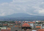
Mount Tangkuban Perah
Bandung, the capital of West Java province, located about 180 km (112 miles) southeast of Jakarta, is the fourth largest city in Indonesia. With over 2.9 million population in 2007 and over 7.2 million people on the greater Bandung regency & metropolitan area, it's one of the most densely populated city in Asia. It's rated the fastest-growing major city / urban region in Indonesia . Its elevation is 768 metres (2,520 ft) above sea level and is surrounded by up to 2,400 m (7,874 ft) high Late Tertiary and Quarternary volcanic terrain. The 400 km² flat of central Bandung plain is situated in the middle of 2,340.88 km² wide of the Bandung Basin; the basin comprises Bandung, the Cimahi city, part of Bandung Regency, part of West BandungSumedang Regency.[3] The basin's main river is the Citarum; one of its branches, the Cikapundung, divides Bandung from north to south before it merges with Citarum again in Dayeuhkolot. The Bandung Basin is an important source of water for drinking water, irrigation and fisheries, and its 6,147 million m³ of groundwater is a major reservoir for the city.
The northern part of the city is hillier than the rest; the distinguished truncated flat-peak shape of the Tangkuban Perahu volcano (Tangkuban Perahu literally means 'up-turned boat') can be seen from the city to the north. Long-term volcanic activity has created fertile andisol soil in the north, suitable for intensive rice, fruit, tea, tobacco and coffee plantations. In the south and east, alluvial soils deposited by the Cikapundung river are mostly found.
Geological data shows that the Bandung Basin is located on an ancient volcano, known as Mount Sunda, erected up to 3,000–4,000 metres (9,850–13,100 ft) during the Pleistocene age. Two large scale eruptions took place; the first formed the basin and the other (est. 55,000 Before Present) blocked the Citarum river, turning the basin into a lake known as "the Great Lake of Bandung". The lake drained away; the reason for which is the subject of ongoing debate among geologists.
Due to its elevation, the climate in Bandung is cooler than most Indonesian cities and can be classified as humid; the average temperature is 23.6 °C (74.5 °F) throughout the year.The average annual rainfall ranges from 1,000 millimetres in the central and southeast regions to 3,500 millimetres in the north of the city. The wet season conforms with other Indonesian regions, around November to April.

History


The Dutch-built Gedung Sate

The Historical Asia-Afrika Street, Bandung
The earliest reference to the city dates back to 1488, but archaeological findings suggest a type of Homo erectus species had lived on the banks of the Cikapundung River and around the old lake of Bandung. During the seventeenth and eighteenth centuries, the Dutch East Indies CompanyJakarta), Bogor, Cianjur, Bandung, Sumedang and Cirebon was built in 1786. In 1809, Louis Napoleon, the ruler of the Kingdom of the Netherlands and its colonies, ordered the Dutch Indies Governor H.W. Daendels to increase the defensive systems of Java against the British from India. Daendels built a road, stretching approximately 1,000 km (621 miles) from the west to the east coast of Java, and passing through Bandung. In 1810, the road was laid down in Bandung and was named De Groote Postweg (or the 'main post road'), the present-day site of Asia-Afrika Street. Under Daendels' orders, R.A. Wiranatakusumah II, the chief administration of the Bandung regency at that time, moved its office from Krapyak, in the south, to a place near a pair of holy city wells (sumur Bandung), the present-day site of the city square (alun-alun). He built his dalemmasjid agung (the grand mosque) and pendopo (public-official meeting place) in the classical orientation.The pendopo faces Tangkuban Perahu mountain, which was believed to have a mystical ambience.
In 1880, the first major railroad between Batavia and Bandung was built, boosting light industry in Bandung. Chinese workers from outside the city flocked in, to help run facilities, services and selling vendor machines. The old Chinatown district in Bandung is still recognisable in the railroad station vicinity. In 1906, Bandung was given the status of gemeente (municipality) and then later as stadsgemeente (city municipality) in 1926.
In the beginning of the 1920s, the Dutch East Indies government made plans to move the capital of Dutch East Indies from Batavia to Bandung. Accordingly, during this decade, the Dutch colonial government started building military barracks, the central government building (Gouvernments Bedrijven, the present-day Gedung Sate) and other government buildings. This plan, however, was cut short by World War II after which the Dutch were not able to re-established their colony.
The fertile area of the Parahyangan Mountains surrounding Bandung supports productive teaFranz Junghuhn introduced the cinchona (kina) plant.Rich plantation owners visited the city on weekends, attracting girls and businessmen from the capital, Batavia. Braga Street grew into a promenade street with cafes, restaurants and boutique shops. Two art-deco style hotels, Savoy Homann and Preanger, were built in the vicinity of the Concordia Society, a club house for the wealthy with a large ballroom and a theatre. The nickname "Parijs van Java" was given to the city.

Gedung Merdeka during the Asian-African Conference in 1955
After the Indonesian Independence in 1945, Bandung was determined as the capital of West Java province. During the 1945–1949 independence struggle against the Dutch when they wanted to reclaim their colonies, Bandung was one of the heaviest battle places. The Dutch military commander set an ultimatum for the Indonesian combatants in Bandung to leave the city. In response, on 24 March 1946, much of the southern part of Bandung was deliberately set alight as the combatants left; an event known as the Bandung Lautan Api or 'Bandung Sea of Flame'.
In 1955, the first Asian-African Conference -- also known as the Bandung Conference -- was held in Bandung, attended by head of states representing twenty-nine countries and colonies from Asia and Africa. The conference venue was at the Gedung Merdeka, the former Concordia Society building. The conference announced 10 points of declaration on world peace promotion and oppositions against colonialism, known as the Declaration of Bandung, which followed by wave of nationalism movements around the globe and remapped the world politics. The conference was also the first international conference of colored people in the history of mankind.Richard Wright in his book, The Color Curtain, captured the epic meanings of the conference for people of color around the world.Even black freedom movement activists in the United States referred Bandung as Afro-Asian solidarity in 1960s.
In 1987, the city boundary was expanded with the Greater Bandung (Bandung Raya) plan; a relocation of higher concentration development outside the city in an attempt to dilute some of population in the old city. During its development, however, the city core is often uprooted, old faces are torn down, lot sizes regrouped, and what was idyllic residence is bustling chain supermarkets and rich banks.

Lampung


Lampung is a province of Indonesia, located on the southern tip of the island of Sumatra. It borders the provinces of Bengkulu and South Sumatra. Lampung is the original home of the "Lampung" tribe, who speak a distinct language from other people in Sumatra and have their own alphabet.

The province has a population of 6,654,354 (As of 2000[update] census). A large portion of the current population of Lampung is descended from migrants from Java, Madura, and Bali. These migrants came both spontaneously, in search of more land than was available on the more densely populated islands, as well as part of the government's transmigration program, for which Lampung was one of the earliest and most important transmigration destinations.

Lampung is commonly known for its geographical instability in terms of earthquakes and volcanoes. On May 10 2005, a strong earthquake measuring 6.4 on the richter scale struck the province. The historical volcano blast of Krakatau occurred in 1883, which resulted in disastrous consequences.

Textile

Up until the 1920s, Lampung had a rich and varied weaving tradition. Lampung weaving used a supplementary weft technique which enabled coloured silk or cotton threads to be superimposed on a plainer cotton background. The most prominent Lampung textile was the palepai, ownership of which was restricted to the Lampung aristocracy of the Kalianda Bay area.There were two types of smaller cloths, known as tatibin and tampan, which could be owned and used by all levels of Lampungese society. Weaving technologies were spread throughout Lampung. High quality weavings were produced by the Paminggir, Krui, Abung and Pesisir peoples. Production was particularly prolific among the people of the Kalianda Bay area in the south and the Krui aristocracy in the north. The oldest surviving examples of Lampung textiles date back to the eighteenth century,[citation needed] but some scholars believe that weaving may date back to the first millennium AD when Sumatra first came under Indian cultural influence.The prevalence of Buddhist motifs, such as diamonds, suggests that the weaving traditions were already active in the time when Lampung came under the Buddhist Srivijayan rule. There are similarities between Lampung weaving and weaving traditions in some parts of modern-day Thailand that experienced cultural contact with Sriwijaya. Lampung textiles were known as 'ship cloths' because ships are a common motif. The ship motif represents the transition from one realm of life to the next, for instances from boyhood to manhood or from being single to married and also represents the final transition to the afterlife. Traditionally, Lampung textiles were used as part of religious ceremonies such as weddings and circumcisions. For instance, the palepai cloths were used as long ceremonial wall-hangings behind the bridal party in aristocratic marriages. The smaller, more humble tampan cloths were exchanged between families at the time of weddings. Production of many fine cloths blossomed in the late nineteenth century as Lampung grew rich on pepper production, but the devastating eruption of Krakatoa in 1883 destroyed many weaving villages in the Kalianda area.[citation needed] By the 1920s the increasing importance of Islam and the collapse of the pepper trade brought production to a halt.Today Lampung textiles are highly prized by collectors.

Lombok

Lombok (population 2,950,105 in 2005) is an island in West Nusa Tenggara province, Indonesia. It is part of the chain of the Lesser Sunda Islands, with the Lombok Strait separating it from Bali to the west and the Alas Strait between it and Sumbawa to the east. It is roughly circular, with a "tail" to the southwest, about 70 km across and a total area of about 4,725 km² (1,825 sq mi). The administrative capital and largest city on the island is Mataram.

History

The Dutch first visited Lombok in 1674 and settled the eastern most part of the island, leaving the western half to be ruled by a Hindu dynasty from Bali. The Sasaks chafed under Balinese rule, and a revolt in 1891 ended in 1894 with the annexation of the entire island to the Netherlands East Indies.

Geography and demographics

Gunung Rinjani

The Lombok Strait marks the passage of the biogeographical division between the fauna of the Indomalayan ecozone and the distinctly different fauna of Australasia that is known as the Wallace Line, for Alfred Russel Wallace, who first remarked upon the distinction between these two major biomes.

The island's topography is dominated by the centrally-located stratovolcano Mount Rinjani, which rises to 3,726 m (12,224 ft), making it the third-highest in Indonesia. The most recent eruption of Rinjani was in June-July, 1994. The volcano, and its sacred crater lake, 'Segara Anak' (child of the sea), are protected by a National Park established in 1997. The southern part of the island is a fertile plain where corn, rice, coffee, tobacco, and cotton are grown.

The island's inhabitants are 85% Sasak (a people, related to the Balinese, but mostly practising Islam), 10-15% Balinese, with the small remainder being Chinese, Arab, Javanese, and Sumbawanese.


Yogyakarta

The Special Region of Yogyakarta (Indonesian: Daerah Istimewa Yogyakarta, or DIY), is the smallest province of Indonesia (excluding Jakarta). It is located on the island of Java. It is the only province in Indonesia that is still formally governed by a precolonial Sultanate: the Sultanate of Ngayogyakarta Hadiningrat. In English it is pronounced /ˌdʒoʊgdʒəˈkɑrtə/, which derives from its Dutch spelling Jogjakarta. In Javanese (and Dutch) it is pronounced [jogjaˈkartɔ].


Geography
Yogyakarta is located in south-central Java. It is surrounded by the province of Central Java (Jawa Tengah) and the Indian Ocean in the south. The population of DIY in 2003 was approximately 3,000,000. The province of Yogyakarta has a total area of 3,185.80 km². Yogyakarta has the second-smallest area of the provinces in Indonesia, after the Jakarta Capital Region. However it has, along with adjacent areas in Central Java, some of the highest population densities of Java.


History

The Yogyakarta Sultanate, formally the Sultanate of Ngayogyakarta Hadiningrat, was formed in 1755 when the existing Sultanate of Mataram was divided by the Dutch East India CompanyTreaty of Giyanti. This treaty states that the Sultanate of Mataram was to be divided into the Sultanate of Ngayogyakarta Hadiningrat with Yogyakarta as the capital and Mangkubumi who became Sultan Hamengkubuwono I as its Sultan and the Sultanate of Surakarta Hadiningrat with Surakarta as the capital and Pakubuwono III who was the ruler of the Sultanate of Mataram as its Sultan. The Sultan Hamengkubuwono I spent the next 37 years building the new capital, with the Kraton as the centerpiece and the court at Surakarta as the blueprint model. By the time he died in 1792, his territory exceeded Surakarta's. (VOC) in two under the
The ruler Sri Sultan Hamengkubuwono IX (April 12, 1912 - 1988) held a degree from the Dutch Leiden University, and held for a time the largely ceremonial position of Vice-President of Indonesia, in recognition of his status, as well as Minister of Finance and Minister of Defense.
In support of Indonesia declaring independence from the Dutch and Japanese occupation, in September 5, 1945, Sri Sultan Hamengkubuwono IX of Yogya and Sri Paku Alam VIII in Yogya declared their sultanates to be part of the Republic of Indonesia. In return for this support, a law was passed in 1950 in which Yogyakarta was granted the status of province Daerah Istimewa (Special Region Province), with special status that recognizes the power of the Sultan in his own region's domestic affairs.
By this act, Sultan Hamengkubuwono IX was appointed as governor for life. During the Indonesian National Revolution against the Dutch after World War II (1945-1950), the capital of the newly-declared Indonesian republic was temporarily moved to Yogyakarta when the Dutch reoccupied Jakarta from January 1946 until August 1950.
The current ruler of Yogyakarta is his son, Sri Sultan Hamengkubuwono X, who holds a law degree from Universitas Gadjah Mada. Upon the elder sultan's death, the position of governor, according to the agreement with Indonesia, was to pass to his heir. However, the central government at that time insisted on an election. In 1998, Sultan Hamengkubuwono X was elected as governor by the provincial house of representatives (DPRD) of Yogyakarta, defying the will of the central government. "I may be a sultan," he has been quoted in Asia Week as saying, "but is it not possible for me to also be a democrat?"
See also List of Governors of Yogyakarta See also Yogyakarta Sultanate

2006 Earthquake

Main article: May 2006 Java earthquake The province of Yogyakarta bore the brunt of a 6.3-magnitude earthquake on 27 May 2006 which killed 5,782 people and left some 36,299 persons injured. More than 135,000 houses are damaged, and 600,000 people are homeless. The earthquake extensively damaged the local region of Bantul, and its surrounding hinterland. The most significant number of deaths occurred in this region.
The coincidence of the recent eruption of Mount Merapi, and the earthquake would not be lost on the older and more superstitious Javanese - as such natural phenonomena are given considerable import within their understanding of the spiritual aspect of such events.

Bali

Bali is an Indonesian island located at 8°25′23″S 115°14′55″E / 8.42306°S 115.24861°E / -8.42306; 115.24861Coordinates: 8°25′23″S 115°14′55″E / 8.42306°S 115.24861°E / -8.42306; 115.24861, the westernmost of the Lesser Sunda Islands, lying between Java to the west and Lombok to the east. It is one of the country's 33 provinces with the provincial capital at Denpasar towards the south of the island.
minority. 93.18% of Bali's population adheres to With a population recorded as 3,151,000 in 2005, the island is home to the vast majority of Indonesia's small HinduBalinese Hinduism, while most of the remainder follow Islam. It is also the largest tourist destination in the country and is renowned for its highly developed arts, including dance, sculpture, painting, leather, metalworking
and music.


History

Bali was inhabited by Austronesian peoples by about 2000 BCE who migrated originally from Taiwan through Maritime Southeast Asia. Culturally and linguistically, the Balinese are thus closely related to the peoples of the Indonesian archipelago, the Philippines, and Oceania.Stone tools dating from this time have been found near the village of Cekik in the island's west.

Balinese culture was strongly influenced by Indian and Chinese, and particularly Hindu culture, in a process beginning around the 1st century AD. The name Balidwipa has been discovered from various inscriptions, including the Blanjong charter issued by Sri Kesari Warmadewa in 913 AD and mentioning Walidwipa. It was during this time that the complex irrigation system subak was developed to grow rice. Some religious and cultural traditions still in existence today can be traced back to this period. The Hindu Majapahit Empire (1293–1520 AD) on eastern Javacolony in 1343. When the empire declined, there was an exodus of intellectuals, artists, priests and musicians from Java to Bali in the 15th century. founded a Balinese

The first European contact with Bali is thought to have been made by Dutch explorer Cornelis de Houtman who arrived in 1597, though a Portuguese ship had foundered off the Bukit Peninsula Dutch colonial control was expanded across the Indonesian archipelago in the nineteenth century (see Dutch East Indies). Their political and economic control over Bali began in the 1840s on the island's north coast by playing various distrustful Balinese realms against each other. In the late 1890s, struggles between Balinese kingdoms in the island's south were exploited by the Dutch to increase their control. The Dutch mounted large naval and ground assaults at the Sanur region in 1906 and were met by the thousands of members of the royal family and their followers who marched to certain death against superior Dutch force in a suicidal puputan defensive assault rather than face the humiliation of surrender.Despite Dutch demands for surrender, an estimated 4,000 Balinese marched to their death against the invaders. In 1908, a similar massacre occurred in the face of a Dutch assault in Klungkung. Afterwards the Dutch governors were able to exercise little influence over the island, and local control over religion and culture generally remained intact. as early as 1585.

Dutch rule over Bali had come later and was never as well established as in other parts of Indonesia such as Java and Maluku. Imperial Japan occupied Bali during World War II during which time a Balinese military officer, Gusti Ngurah Rai, formed a Balinese 'freedom army'. In the 1930s, anthropologists Margaret Mead and Gregory Bateson, and artists Miguel CovarrubiasWalter Spies, and musicologist Colin McPhee created a western image of Bali as "an enchanted land of aesthetes at peace with themselves and nature", and western tourism first developed on the island. Following Japan's Pacific surrender in August 1945, the Dutch promptly returned to Indonesia, including Bali, immediately to reinstate their pre-war colonial administration. This was resisted by the Balinese rebels now using Japanese weapons. On 20 November 1946, the Battle of Marga was fought in Tabanan in central Bali. Colonel I Gusti Ngurah Rai, 29 years old, finally rallied his forces in east Bali at Marga Rana, where they made a suicide attack on the heavily armed Dutch. The Balinese battalion was entirely wiped out, breaking the last thread of Balinese military resistance. In 1946 the Dutch constituted Bali as one of the 13 administrative districts of the newly-proclaimed Republic of East Indonesia, a rival state to the Republic of Indonesia which was proclaimed and headed by Sukarno and Hatta. Bali was included in the "Republic of the United States of Indonesia" when the Netherlands recognised Indonesian independence on29 December 1949.

And The 1963 eruption of Mount Agung killed thousands, created economic havoc and forced many displaced Balinese to be transmigrated to other parts of Indonesia. Mirroring the widening of social divisions across Indonesia in the 1950s and early 1960s, Bali saw conflict between supporters of the traditional caste system, and those rejecting these traditional values. Politically, this was represented by opposing supporters of the Indonesian Communist PartyIndonesian Nationalist Party (PNI), with tensions and ill-feeling further increased by the PKI's land reform programs.An attempted coup in Jakarta was put down by forces led by General Suharto. The army became the dominant power as it instigated a violent anti-communist purge,

in which the army blamed the PKI for the coup. Most estimates suggest that at least 500,000 people were killed across Indonesia, with an estimated 80,000 killed in Bali, equivalent to 5 per cent of the island's population. With no Islamic forces involved as in Java and Sumatra, upper-caste PNI landlords led the extermination of PKI members.

As a result of the 1965/66 upheavals, Suharto was able to maneuver Sukarno out of the presidency, and his "New Order" government reestablished relations with western countries. The pre-War Bali as "paradise" was revised in a modern form, and the resulting large growth in tourism has led to a dramatic increase in Balinese standards of living and significant foreign exchange earned for the country. A bombing in 2002 by militant Islamists in the tourist area of Kuta killed 202 people, mostly foreigners. This attack, and another in 2005, severely affected tourism, bringing much economic hardship to the island.

Geography

See also List of bodies of water in Bali and List of mountains in Bali.
Topography of the island

The island of Bali lies 3.2 km (2 mi) east of Java, and is approximately 8 degrees south of the equator. East to west, the island is approximately 153 km (95 mi) wide and is approximately 112 km (69 mi) north to south; it's land area is 5,632 km². The highest point is Mount Agung at 3,142 m (10,308 feet) high, an active volcano that last erupted in March 1963. Mountains cover centre to the eastern side, with Mount Agung the easternmost peak. Mount Batur (1,717 m) is also still active; an eruption 30,000 years ago was one of the largest known volcanic events on Earth.

In the south the land descends to form an alluvial plain, watered by shallow, north-south flowing rivers, drier in the dry season and overflowing during periods of heavy rain. The longest of these rivers, Sungai Ayung, is also the longest on the island (approx. 75 km).

The principal city is the present provincial capital and largest city, Denpasar, near the southern coast. Its population is around 300,000. Bali's second-largest city is the old colonial capital, Singaraja, which is located on the north coast and is home to around 100,000 people. Other important cities include the beach resort, Kuta, which is practically part of Denpasar's urban area; and Ubud, which is north of Denpasar, and known as the island's cultural centre.


Southern Bali in the foreground and Mount Agung behind

There is a coastal road surround the island, as well as three major two-lane arteries that cross the central mountains at passes reaching to 1,750m in height (at Penelokan). Minor roads branch off of these major highways. The Ngurah Rai Bypass is a four-lane expressway that partly encircles Denpasar and enables cars to travel quickly in the heavily populated south. Bali has no railway lines.

The island is surrounded by coral reefs. Beaches in the south tend to have white sand while those in the north and west have black sand. The beach town of Padangbai in the south east has both. Bali has no major waterways, although the Ho River is navigable by small sampan boats. Black sand beaches between Pasut and Klatingdukuh are being developed for tourism, but apart from the seaside temple of Tanah Lot, they are not yet used for significant tourism.

To the east, the Lombok Strait separates Bali from Lombok and marks the biogeographicalIndomalayan ecozone and the distinctly different fauna of Australasia. The transition is known as the Wallace Line, named after Alfred Russel Wallace, who first proposed a transition zone between these two major biomes. When sea levels dropped during the Pleistocene ice age, Bali was connected to Java and Sumatra and to the mainland of Asia and shared the Asian fauna, but the deep water of the Lombok Strait continued to keep Lombok and the Lesser Sunda archipelago isolated.